Maxent tool for ArcGIS Pro in species modeling
The Maxent tool for ArcGIS Pro is now available starting with versions 2.9. The mythical species distribution modeling tool already has a clone within the ArcGIS Pro geoprocessing tools, and you will not need to complicate the adaptation of variables and coordinates that Maxent originally requires. From your coordinates and variables, whatever your starting conditions, you can carry out the modeling of species.
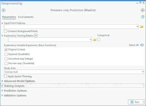
From the analysis tools you can access the Presence-only Prediction (Maxent) tool, an emulation of the original tool within the ArcGIS Pro environment that does not require the addition of auxiliary toolboxes or direct gateways to the .JAR executable.
The tool presents the same parameterization as Maxent, having to incorporate the raster environmental variables and the distribution coordinates. What is interesting about the tool? That you will not need to adapt the data to Maxent's requirements by managing pixel sizes, generating CSV of coordinates or exporting variables to ASCII formats. From the Maxent tool for ArcGIS Pro you can view your starting coordinates and raster environmental variables to incorporate them directly into the tool and get your results in the work view regardless of the starting formats.
Maxent for ArcGIS Pro will allow you to use the initial coordinate files and restricted to the surfaces of the environmental variables, being able to use different analysis surfaces or work with descriptive fields of presence and absence. You will be able to incorporate rasters under any file format, being able to label them as categorical or continuous (default value).
Depending on the number of available coordinates, you can adjust the model under the traditional Linear, Quadratic, Product, Hinge and Threshold options.
Your key output parameters will be found in the Training Outputs section, where you can select the modeling output directory and save the response curves of the variables or the ROC curve as Maxent did.
Once you have the distribution modeled, ArcGIS Pro will display and symbolize the model in the view by adding query tables and charts to the model.
If you have a version of ArcGIS Pro and you don't want to adapt the variables and coordinates to Maxent's input premises, this may be your tool, working simultaneously with the variables management environment and the species distribution modeling environment. If you want to continue working with the native Maxent tool, you can browse through these entries the necessary premises to adapt your files through ArcGIS, QGIS or gvSIG:


Comments
Post a Comment