Global Climate Data Download
Perhaps one of the most difficult information to obtain is climate mapping based on values of temperature, precipitation or humidity. Usually, this little information is found in raster format or in simple data tables. And although the information may be scarce on the Internet, there are places to obtain this type of data. Let's see where we can download climate cartography.
The Global Climate Monitor is also another option that we can use to obtain climate information. From this interesting platform we will be able to consult the global climatic data of various variables and consult the documentary source from which they come. We can also download the information of stations or complete territorial zones in CSV, XLSS, SHAPE or KML formats.

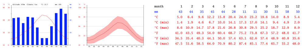
Climate-Data also offers us climatic information from anywhere in the world, although this time we will not have cartographic information but the climatological data itself in the form of graphs and tables. Information based on tables is offered by the WMO (World Meteorological Organization) where we will find countless climatic indicators.

Global Weather Data for SWAT: it has a database of stations distributed throughout the world (except for the polar areas) through which you can locate the position of the stations and interpolate the data of five main climatic variables available since 1979.

Climate Engine can be one of the best platforms to work with, being able to access countless climatic variables and indicators derived from satellite images. The platform accesses Google Earth Engine data collections, allowing you to download raw and preprocessed data or generating time series of values for defined territorial areas. Surely one of the most unknown applications with the greatest potential for downloading climate maps.

ERA5-Land is the resource offered by Copernicus to access climatic variables with global coverage since 1981 and with a recurrence of one hour . In addition to climate data, you will also find information linked to variables such as vegetation or water bodies. You can download the datasets from the Copernicus platform or process long time series of data from the collections available in Google Earth Engine.


Comments
Post a Comment